
Discuss your preferences, but don’t be in a hurry to decide how you will get around. After reading this section you’ll see why. This is a single long page because it all fits together.
A later page will discuss how to use the toolkit you’ve built here to generate ground-level details.
Subway-train-tram-bus?
We like subways and trains. They travel faster, their stations are easy to find and usually out of the weather. Trams are almost as good and often have very convenient stops. In major cities, subways are astonishingly frequent, so you needn’t worry about timing.
In many places in Europe and Asia, trains are almost always exactly on time*. Buses vary, but note that they will be on time at major transfer points and especially at the start of their run – which is often a subway or train station.
- In 2019, a Japanese train company took a full-page newspaper ad to apologize because one of their trains left 30 seconds early.
But the last leg of your trip might require a bus. Or your city might have specific tourist-oriented buses that whisk you directly from a key station to a major attraction.
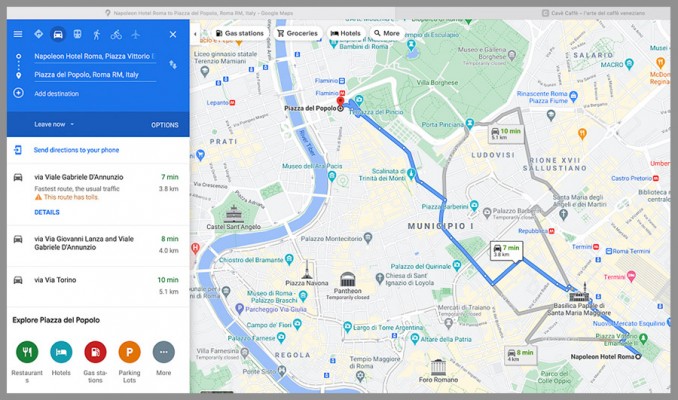
I use Google Maps–the regular kind, not My Maps–to do initial point-to-point planning. It usually shows you several options you can start planning with. It is also pretty good at knowing how long it will take you to connect between lines, and how to do it. Tokyo, for example, has some HUGE stations; it can take ten minutes to cross them, and you can get lost.
Further down this page I’ll discuss how to get city transit into your Google Map.
Pass, tickets, whatever
For each city, you’ll want to consider how to pay for transport. And that can often be tied to admission tickets for sights.
When you’re ready to tackle that. hop over to the Passes page.
Airport transfers
TAXIS: You can take a taxi/Uber/Lyft any time. If you’ve read this far, you don’t like to spend that kind on money.
But it’s worth it if:
- You haven’t done your transit homework yet (see below)
- Your trip to or from the airport is at oh-dark-hundred and many transit options are unavailable or infrequent, or perhaps you just don’t feel safe at that time
TRANSIT: In most major cities, you will have at least two choices on how to get to and from the airport by transit. This decision is an important part of your process for choosing your hotel.
- On arrival at your target city, you’ll probably be tired. How much will you want to schlep a suitcase and a carryon and a map? How about all that AND you have to change trains in midtown?
- On our last visit to Paris, we chose a hotel near the Nation métro station, because it is one of the stops for the fast RER train from the airport. This was a GOOD idea.
Transfer options
- Try to avoid transfers. You can usually find a place where at worst you take one ride into the city and one ride within it. But give a hotel an extra point if you can reach it in one!
- There will often be a fast train with few stops, and a slower train with more stops. The fast one won’t usually cost a lot more, and it will probably be more comfortable, with more room for your stuff.
- A couple of special cases:
- London’s Heathrow Express is very expensive. Consider other options.
- Toronto’s UP Express is a real bargain, especially for seniors. It will whisk you downtown, or you can connect to the subway at a couple of stops.
- Some cities offer a bewildering array of options, with trains that split or may require a transfer. When you hit this, go to Trip Advisor or some similar site, and search for advice. The more complicated the situation, the more likely you will be able to find advice. Or just search for a simple one among the nasties.
Late or early? Consider a night near the airport
- We had a morning flight from London, and our previous stop was Reading, just northwest of London. Google said to take the train east into London and get the westbound airport express. But there’s a “railbus” directly to Heathrow, same travel time, half the price and no transfers. AND we ended up in an airport hotel at 1/4 the price of a decent hotel in the city.
- We arrived at Osaka after 9 p.m. But the hotel AT the airport has good rices. From bag pickup, we walked four minutes under cover (it was raining) and checked in. Next day we walked back to the airport and took a train to the city.
Mapping your transit
Here’s my plan for Paris. It shows the places I’m considering for the area shown.

and here’s the same map with a transit layer added:
See where we’re going with this?
Below I’ll show you how to add that transit layer, if your city has a map for it.
KML transit maps
You are now finding out why this site is called “tripgeek.”
If you’re going somewhere like Tokyo or London or Paris, you HAVE to find a good transport map. Life gets so much easier if you can integrate it with your planning map.
KML is the file extension for an unzipped file, while KMZ is the zipped version of a KML file. 3. KML is used to save and store map locations in general, while KMZ is used in the same capacity for more specific locations like placemarks. We’ll look for KMLs, but KMZs are fine.
Try it:
- If you Google, for example, “kml map london tube” you will see several reasonable possibilities. Look for hints that they are official, and that they are specific to your needs
- Download one.
- Open that city’s map in your Google My Maps.
- Create a new layer and Import the KML file. This is where you go, “Whoa, how cool is that?”
- Decide if this is workable. It might have too many or too few lines, stations or places.
If it isn’t try another one. Some cities just don’t have one and you’ll have to find another way. - Try Googling “Bakerloo Line KML,” for example, but note that many cities have a lot of lines!
- Because this is a separate layer in your My Map, you can toggle its visibility while you plan other aspects.
Not all maps are useful:
- Taipei KML was too big and labelled in Chinese
- In Paris, I found one for the Métro subway and RATP trains (good) AND one for Metro Connections (not really useful but led to more research)
What you need to find out
For any given trip, start with Google Maps (not your my Maps) and ask it how to get from A to B. It will provide several options and LOTS of detail.
Train:
- Number, frequency, platform, times that suit you
- Type of train: many countries offer some version of slow local, faster regional, and high-speed longer-distance. They can differ quite a lot in time, cost, and frequency. Pick one, and record the time and fare.
- Fare – watch for rush-hour premiums
- Which station you want – for example, Amsterdam Sud can be much more convenient than Centraal
- How and when you pay and board
- Your friend for this is seat61.com
Bus & tram
- Number, frequency
- stop locations at both ends (use Google Maps, and don’t hesitate to go to street view until you actually SEE the stop; this may lead you to conclude that another stop might work better for you)
- How and when you pay and board
Big stations (train or bus)
- If either end of your trip is in a big station, find out your arrival and departure points in the station; Google’s estimates of transfer time assume that you know where you are going (it does give instructions)
- Google’s trip planning will sometimes, in the fine print, tell you to use a particular exit. Trust them!
- When researching locations, look on the place’s website for directions. They will often tell you useful things like what exit to use from nearby stations.
- For huge stations, search for a guide page and map. Here’s Kyoto Station, for example. If you look around a bit, you can often find someone’s blog with very detailed instructions and photos on how to get through the station.
Toilets
- We have a whole page on toilets, but while you’re here, remember that in a big city it can take a while to get from A to B, or should I say A to P? Maybe use the link above to add that feature to your travel plan.